-

History of Pleasant View area including State Line School, Mill Creek School, big Rock School, Pleasant View School and the merger with Post Falls School District 273. Includes biographies and genealogies for residents between 1888 and 1910
-
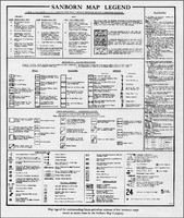
Legend for Sanborn Maps
-
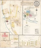
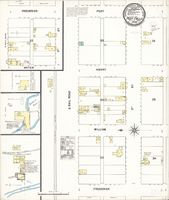
Sanborn Fire Insurance Map from Post Falls, Kootenai County, Idaho. Item is held by the Library of Congress.
-
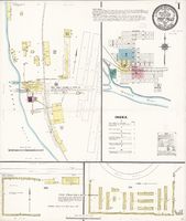
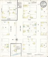
Sanborn Fire Insurance Map from Post Falls, Kootenai County, Idaho. Item is held by the Library of Congress.
-
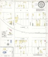
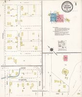
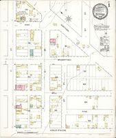
Sanborn Fire Insurance Map from Post Falls, Kootenai County, Idaho. Held by the Library of Congress.
-
Sanborn Fire Insurance Map from Post Falls, Kootenai County, Idaho. Held by the Library of Congress.
-
Sanborn Fire Insurance Map from Post Falls, Kootenai County, Idaho. Held by the Library of Congress.
-
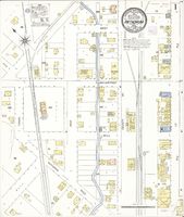
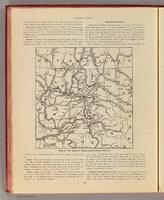
Sanborn Fire Insurance Map from Rathdrum, Kootenai County, Idaho. Held by the Library of Congress.
-
Sanborn Fire Insurance Map from Rathdrum, Kootenai County, Idaho. Held by the Library of Congress.
-
Sanborn Fire Insurance Map from Rathdrum, Kootenai County, Idaho. 1892. Held by the Library of Congress
-
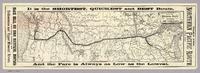
Map of the Northern Pacific Railroad and connections. Relief shown by hachures. Covers area from Lake Michigan to Oregon and Washington. Scale 1:7,500,000
-
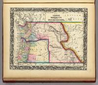
Map Of Oregon, Washington, And Part Of British Columbia. Washington and Oregon in full color by county or region. Scale 1:4,000,000
-
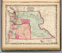
Johnson's Washington And Oregon By Johnson & Browning. No. 46. In full color by county or region. Proposed route of the Pacific Railroad shown. Scale 1:4,688,640
-
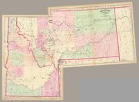
Composite of 2 maps. Hand col. engraved map. Relief shown by hachures and spot heights. Shows townships, etc. Prime meridians: Greenwich and Washington. Scale 1:1,267,200
-
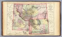
County and township map, Montana, Idaho and Wyoming. Copyright 1887 by Wm. M. Bradley & Bro. (1890). Hand colored. Relief shown by hachures. Shows settlements, Indian reservations, railroads, rivers, etc. Prime meridians: Greenwich and Washington. Scale 1:2,600,000
-
Map of the Eastern-Washington-Idaho Region. Designed & engraved by the American Engraving Co., Spokane. (Published by Ellis A. Davis. Berkeley, Cal. Seattle. 1909). Black and white map. Shows settlements, railroads, etc. Covers also portions of Montana, Oregon and British Columbia.
-
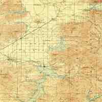
USGS Map of Rathdrum, Post Falls, and area around Lake Coeur d'Alene and Hayden Lake
-
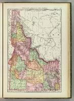
Col. map. Relief shown by hachures. Title in margin: Indexed atlas of the world. Idaho. Rand, McNally & Co.'s new business atlas map of Idaho. Copyright, 1892, by Rand, McNally & Co. (Chicago, 1897). Scale 1:1,700,000
-
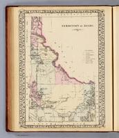
Territory of Idaho. 1876. (Entered ... 1879 by S. Augustus Mitchell ... Washington. 1880). Hand colored. Relief shown by hachures. Shows counties, Indian reservations, townships, settlements, rivers, etc. Prime meridians: Greenwich and Washington. Scale 1:2,400,000
-
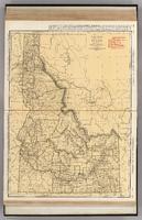
Commercial Atlas of America. Rand McNally Standard Map of Idaho. Shows railroads and distances. Includes tables of principal cities and railroads, keyed to map. Relief shown by hachures. Scale 1:1,267,000